
Appendix
This chapter lists the Lixel L3 specifications and storage guidance.
Specifications
| Category | Item | Lixel L3 (16 / 32-channel) |
|---|---|---|
| Hardware | Dimensions | 206mm × 107mm × 329mm |
| Power consumption | <30W | |
| Weight [1] | Approx. 2.5 kg | |
| Data interface | USB 3.1 Gen2 | |
| Internal storage | UFS 1TB | |
| RTK module | Supported (built-in) | |
| WiFi | 802.11 a/b/g/n/ac/ax 2.400 GHz – 2.4835 GHz 5.15 GHz – 5.850 GHz | |
| Bluetooth | Bluetooth v2.1+EDR/3.0+HS/4.2/5.0/5.2 · 2.4 – 2.4835 GHz | |
| Housing | Aluminum alloy | |
| Total operating time | 100 min | |
| Operating Environment | Operating temperature | -20℃ to 50℃ |
| Ingress protection | IP54 | |
| Battery | Battery voltage | 14.4V |
| Battery capacity | 3350 mAh | |
| Display | Size | 4.3" TFT |
| Brightness | Up to 1,000 nits | |
| Resolution | 480 × 800 | |
| Survey-Grade GNSS Module | Signals tracked | BDS B1I, B3I, B1C, B2a, B2b GPS L1C/A, L1C, L2C, L2P(Y), L5 GLONASS G1, G2, G3 Galileo E1, E5a, E5b, E6 QZSS L1C/A, L1C, L2C, L5, L6 IRNSS L5 SBAS L1C/A |
| Accuracy | Horizontal: 0.8 cm + 1 ppm Vertical: 1.5 cm + 1 ppm | |
| Peak gain | 4.0dBi | |
| Azimuth coverage | 360° | |
| Impedance | 50 Ω | |
| Polarization | Right-hand circular (RHCP) | |
| Axial ratio | ≤3dB | |
| Output VSWR | ≤2.0 | |
| LiDAR Module | Laser class | Class 1 (905nm) |
| Range | 0.7 – 120m | |
| Field of view | 360° × 270° | |
| Scanning | Mobile | |
| Point rate | 320,000 / 640,000 pts/s | |
| LiDAR channels | 16 / 32 | |
| Vision Module | Forward camera | 1 |
| Forward camera FOV | 100° × 75° | |
| Panoramic cameras | 2 | |
| Panoramic camera field of view | 200° × 200° | |
| Camera resolution | 4096 × 3072 | |
| CMOS sensor size | 1/1.3” | |
| Shutter | Rolling shutter | |
| HDR [2] | DCG HDR | |
| Accuracy | Post-processed relative accuracy (1σ) [3] | 5 mm (500 m² test env.) |
| Post-processed point cloud thickness [4] | ≤ 5mm | |
| Absolute accuracy, vertical (RMSE) [5] | 2 cm | |
| Absolute accuracy, horizontal (RMSE) [5] | 2 cm | |
| Repeatability [5] | 2 cm | |
| Real-time relative accuracy [6] | 1 cm | |
| Real-time absolute accuracy, vertical (RMSE) [7] | 2.5 cm | |
| Real-time absolute accuracy, horizontal (RMSE) [7] | 2.5 cm | |
| Leveling (with RTK fusion) [8] | 0.005° | |
| Leveling (without RTK fusion) [9] | 0.02° | |
| Real-time Feature | AI dynamic object removal | Supported |
| AI noise filtering | Supported | |
| True-color point cloud | Supported | |
| Vision-aided positioning | Supported | |
| On-device Feature | Scan assistance system (real-time quality check) | Supported |
| POI panorama preview | Supported | |
| Model preview | Supported | |
| On-model measurement | Supported | |
| Post-processing Feature | Local point cloud enhancement | Supported |
| Control-point-free map fusion | Supported | |
| Stable mapping in low-feature environments | Supported | |
| PPK post-processing | Supported | |
| AI privacy protection | Supported | |
| Point cloud overlay | Supported | |
| LCC (3DGS) single-scene reconstruction | Supported | |
| Mesh reality 3D reconstruction | Supported | |
| Stockpile volume calculation and comparison | Supported | |
| Multi-session fusion and adjustment | Supported | |
| Output Formats | Point cloud | .las .rcp .e57 .ply .ilas |
| Imagery | .jpg | |
| Mesh | .osgb .obj | |
| 3DGS | .lcc2 .lcc .ply | |
| Others | 3D Tiles (.3tz), .usd | |
| Accessories | Base mount | Standard |
| Charging hub | Standard | |
| Portable hard case with backpack system | Standard | |
| Support rig | Optional |
[1] Including battery; other components not included.
[2] DCG HDR extends the sensor's dynamic range, holding detail in both highlights and shadows.
[3] Tested in a dedicated 500 m² test environment; accuracy reported at 1σ. For full details on the test environment and accuracy metrics, see our white paper.
[4] Point cloud planar thickness within a 10 m walking path.
[5] Measured under open sky, free of multipath effects, with optimal GNSS geometry and favorable atmospheric conditions.
[6] Measured under laboratory conditions; actual performance may vary.
[7] Measured under open sky, free of multipath effects, with optimal GNSS geometry and favorable atmospheric conditions. WGS 84 and CGCS2000 only.
[8] Measured under open sky, free of multipath effects, with optimal GNSS geometry and favorable atmospheric conditions. Actual performance may vary.
[9] Measured under laboratory conditions in a 2,000 m² scene without RTK fusion; actual performance may vary.
Storage and Handling
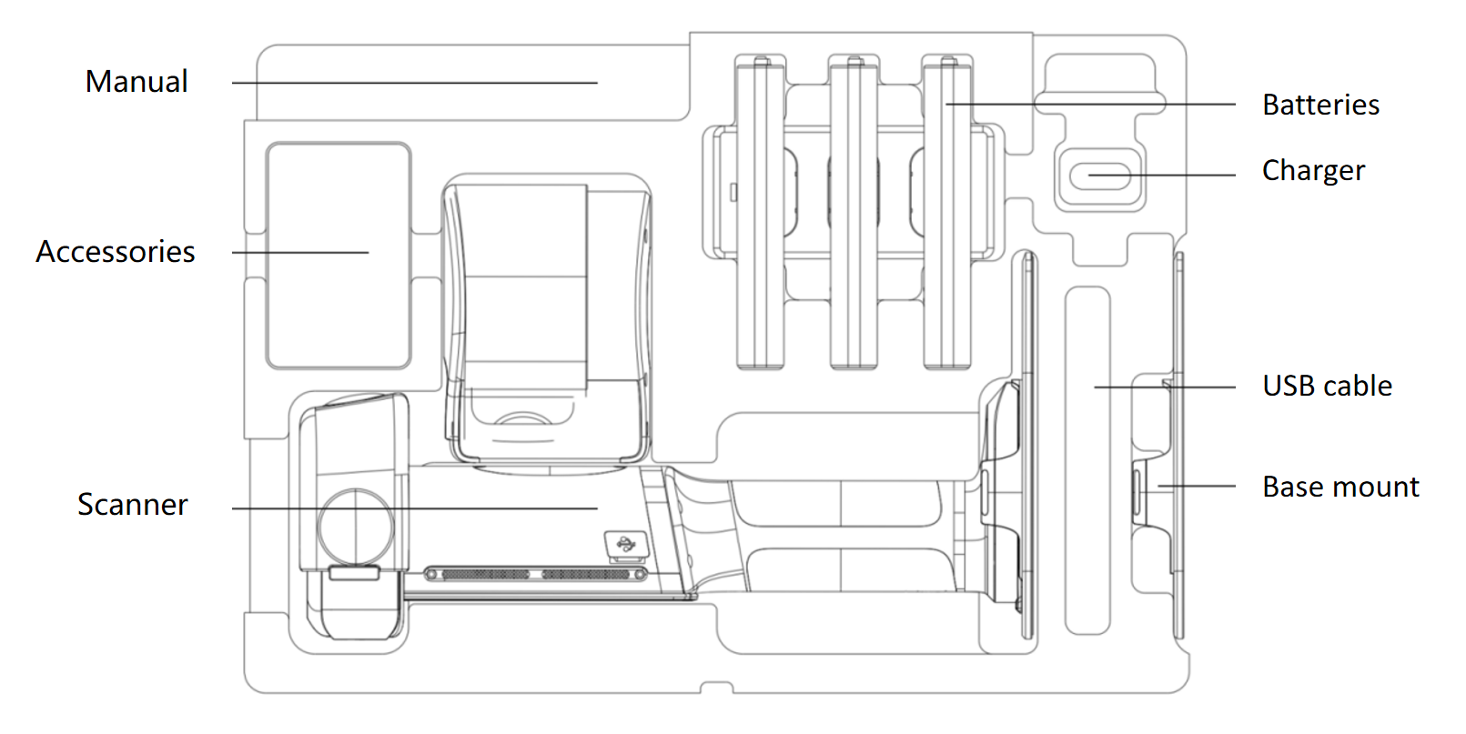
Usage precautions
- The Lixel L3 is a precision surveying instrument. Drops or impacts can damage it and reduce accuracy.
- The Lixel L3 is rated IP54. Do not use it in conditions beyond this rating. Clean it with a soft, dry cloth or the supplied cleaning cloth, and do not touch the LiDAR or lenses with your fingers.
- The body gets hot during use. Avoid touching it to prevent burns.
- Keep the heat dissipation area uncovered. The device may shut down if it overheats.