
Data Flow Overview
This article explains the full workflow from device capture to deliverable, including the output capabilities of each device model, the data flow between software, the distinction between the two kinds of PLY format, multi-segment data merge options, and the paths for importing deliverables into Unity / Unreal / CAD / BIM.
Data Flow at a Glance
General capture and processing workflow:
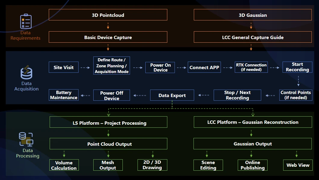
General capture and processing workflow
Notes
- The PortalCam P1 can output only 3DGS deliverables; it cannot output laser point clouds usable for engineering surveying.
- The K / L series can output Point Cloud, Mesh, and 3DGS at the same time. Import the same raw capture data into Lixel Studio and LCC Studio separately for processing; no re-capture is needed.
- For projects, follow the detailed LCC capture guide directly: General Capture Principles; for basic device operation, refer to the standard capture guide for each device on the official website, for example L2 Pro: Basic Device Functions; K2: Route Planning Recommendations.
Output Capabilities of Each Device Model
| Device | Real-time point cloud | Post-processed point cloud | Mesh | 3DGS | Positioning notes |
|---|---|---|---|---|---|
| PortalCam P1 | — | — | — | Yes | Spatial camera; outputs 3DGS only, not for engineering surveying |
| K1 | Yes | Yes | Yes | Yes | Portable model, for small-to-medium scenes |
| K2 | Yes | Yes | Yes | Yes | Lightweight portable model, with advanced 3DGS deliverables |
| L2 Pro | Yes | Yes | Yes | Yes | For large-area continuous capture |
| L3 | Yes | Yes | Yes | Yes | Flagship model, with high accuracy and imagery-grade visual deliverables |
Accuracy reference:
- Post-processed relative accuracy: K1 / K2 about 1 cm, L2 Pro about 1 cm, L3 is 5 mm.
- Real-time direct point cloud accuracy: L3 is relative 1 cm / absolute 2.5 cm (RMSE). The 5 mm relative accuracy can only be reached after post-processing; real-time direct deliverables do not have this accuracy level.
Role of Each Software
| Software | Input | Main functions | Output |
|---|---|---|---|
| LCC Scan App (mobile) | — | Capture monitoring and device control for PortalCam P1 | Raw data stored on the P1 device |
| Lixel Go App (mobile) | — | Capture monitoring, device management, and data download for the K / L series | Stored on the original K / L series device |
| Lixel Studio (desktop) | K / L series raw data | SLAM mapping, point cloud post-processing, point cloud editing, vector drawing, Map Fusion, multi-format export | .las / .laz / .ply (point cloud), .obj / .osgb (Mesh) |
| LCC Studio (desktop) | PortalCam P1 or K / L series data | 3DGS scene reconstruction and rendering | .lcc / .ply (Gaussian) / .sog / .spz / .3d tiles / .usd |
| LCC Model Editor (desktop) | Multiple reconstructed 3DGS scenes | Manual stitching and editing of 3DGS models | Stitched 3DGS model |
| LCC Linux (server) | Large-volume reconstruction | 3DGS scene reconstruction and rendering | .lcc / .ply (Gaussian) / .sog / .spz / .3d tiles / .usd |
Distinguishing Easily Confused Software
- LCC Scan vs Lixel Go: the former is the mobile capture control app dedicated to the PortalCam P1; the latter is the general mobile capture control app for the K / L series. The two are not interchangeable, but their device-connection principle is similar, and both are available on Android and iOS.
- LCC Studio vs LCC Model Editor: the former handles reconstruction from raw data into 3DGS; the latter handles stitching and editing of multiple already-reconstructed 3DGS deliverables. The former is a reconstruction tool, the latter an editing tool.
- Lixel Studio vs LCC Studio: the former outputs point cloud and Mesh, the latter outputs 3DGS. The two are usually used together — the same laser scan data can be imported into Lixel Studio to generate a point cloud and into LCC Studio to generate 3DGS, with no re-capture needed.
Deliverable Format Reference
| Extension | Data nature | Generating software | Compatible software |
|---|---|---|---|
| .las / .laz | Standard laser point cloud | Lixel Studio | CloudCompare, AutoCAD, Revit, SketchUp (plugin required), and mainstream point cloud software |
| .ply (point cloud) | Point cloud format | Lixel Studio | CloudCompare, Blender, MeshLab, etc. |
| .ply (3DGS Gaussian) | 3DGS Gaussian format | LCC Studio | Viewers and plugins that support 3DGS; cannot be opened in regular point cloud software |
| .lcc / .lcc2 (SOG/SPZ) | LCC is a proprietary 3DGS format; LCC2 is a general compressed format | LCC Studio | LCC Viewer, LCC SDK, LCC Editor |
| .obj + .mtl + .jpg texture | Mesh and texture | Lixel Studio | 3ds Max, Maya, Blender, Rhino, SketchUp, and other common 3D software and viewers |
| .osgb | Mesh and texture | Lixel Studio | DasViewer, ContextCapture Viewer, OSGViewer, Supermap, Cesium |
| .dxf / .rcp | Autodesk layer and point cloud format | Lixel Studio | AutoCAD, ReCap |
| .e57 | Point cloud + panoramic photo format | Lixel Studio | ReCap |
| .usd / .usdz | NVIDIA Omniverse dedicated format | LCC Studio | Omniverse Kit |
| 3D Tiles | A tiled 3D data format for WebGIS / digital twins | LCC Studio | Cesium |
Distinguishing the Two Kinds of PLY File
.ply is a general container format. Within XGRIDS deliverables there are two kinds of PLY file with different natures. They share the same extension but have completely different internal data structures and use cases, and must be distinguished.
| Comparison | Point cloud PLY | 3DGS Gaussian PLY |
|---|---|---|
| Generating software | Exported from Lixel Studio | Exported from LCC Studio |
| Internal data structure | Each record is a point, with coordinates and color (x, y, z, r, g, b) | Each record is a Gaussian primitive, with position, scale, orientation, and spherical harmonics coefficients |
| Regular point cloud software (e.g. CloudCompare) | Opens and displays a colored point cloud normally, with high density | Opens with large spacing between points, low density |
| 3DGS viewer | Fails with an error on import | Renders the 3DGS scene |
| File size | Relatively large | Relatively small |
How to Tell Them Apart
- By exporting software: one exported by Lixel Studio is a point cloud PLY, and importing it into LCC Studio will fail; one exported by LCC Studio is a 3DGS PLY, and importing it into Lixel Studio can render it as a realistic scene.
- By file size: the 3DGS PLY of the same scene is significantly smaller than the point cloud PLY.
- By purpose: one used for surveying/modeling, BIM, or format exchange should be a point cloud PLY; one used for display and visual presentation should be a 3DGS PLY.
Typical Workflow Scenarios
Delivering measurement point cloud only, for BIM or CAD work
Applicable scenarios: building surveying, Scan-to-BIM, as-built acceptance, terrain surveying.
Processing workflow:
- Complete on-site capture with K1 / K2 / L2 Pro / L3.
- Import the raw data into the workstation over a USB cable.
- Complete SLAM mapping and point cloud post-processing in Lixel Studio, outputting .las format or generating .obj / .osgb format.
- Import into third-party software (Revit, AutoCAD, SketchUp, CloudCompare, etc.) for subsequent work.
Notes:
- Absolute coordinates can only be obtained by enabling RTK during capture and recording according to the specification; otherwise the deliverable has only relative coordinates.
- Aim for start-to-end closure at the end of capture (returning within 1 m of the start point), so that loop closure optimization can suppress accumulated error.
- Projects requiring 5 mm relative accuracy must use post-processed deliverables and must not substitute real-time direct point cloud.
Delivering 3DGS only, for display or film previs
Applicable scenarios: real estate display, show-home presentation, cultural tourism exhibition halls, film location scouting.
Option A: Use PortalCam P1 (recommended)
- Complete capture with the LCC Scan App.
- Complete 3DGS reconstruction in LCC Studio, outputting .lcc or 3DGS PLY.
- Share to the web via LCC Scene Editor, or integrate into a development platform application via the SDK.
Option B: Use the K / L series
- Complete capture with the Lixel Go App.
- Complete 3DGS reconstruction in LCC Studio.
Option selection advice: when only 3DGS deliverables are needed, the PortalCam P1 workflow is the shortest and most efficient. If the project already requires point cloud output, the K / L series can additionally output 3DGS from the same data, with no need to buy extra devices.
Delivering point cloud, Mesh, and 3DGS from a single capture
Applicable scenarios: projects requiring comprehensive delivery, for example delivering surveying deliverables, as-built documentation, and digital twin models together. The L3 is the recommended model for this scenario.
Processing workflow:
- Complete one on-site capture with the L3.
- Import the raw data into Lixel Studio, outputting point cloud (.las) and Mesh (.obj).
- Import the same raw data into LCC Studio, outputting 3DGS (.lcc or 3DGS PLY).
Note: the same raw capture data can be imported into the two software separately for processing, with no re-capture needed.
Merging Multi-segment Data
The merge option for multi-segment data depends on the data source and capture conditions, and falls into four cases.
| Case | Capture conditions | Merge option |
|---|---|---|
| Same device model, with RTK | All segments enabled, with good RTK GNSS reception | Lixel Studio / LCC Studio Map Fusion (automatic registration based on coordinates) |
| Same device model, without RTK | Segmented capture, with tie points of the same name placed between adjacent segments | Lixel Studio / LCC Studio Map Fusion (automatic registration based on same-name points) |
| Same device model, without RTK | Segmented capture, no same-name tie points between adjacent segments, with overlapping trajectory (10 m) | Lixel Studio tie-point-free Map Fusion (registration based on selected-area features) |
| Aerial data and ground data | K / L + drone need good RTK GNSS; P1 camera + drone need no RTK | LCC Studio Aerial-Ground Map Fusion workflow (see "Aerial-Ground Map Fusion Workflow") |
| Gaussian deliverables from different sources or of different types | For example two already-reconstructed 3DGS scenes | LCC Model Editor manual stitching |
Importing Deliverables into Unity / Unreal / Web / Mobile / VR
| Target platform | Corresponding SDK | Input format |
|---|---|---|
| Unity (desktop and mobile) | LCC Unity SDK | .lcc or 3DGS PLY |
| Unreal | LCC Unreal SDK | .lcc or 3DGS PLY |
| Web browser | LCC Web SDK | .lcc or 3DGS PLY |
| VR (Pico4 Ultra, Quest3) | LCC Unity SDK | .lcc or 3DGS PLY |
Notes:
- The LCC Unity SDK does not support WebGL packaging. Web requirements must use the LCC Web SDK and cannot be achieved via Unity WebGL.
- Point cloud and Mesh deliverables do not go through the XGRIDS SDK. Such deliverables are integrated via the corresponding import plugins in third-party software.
Clarifying Common Misconceptions
Misconception 1: "The PortalCam P1 can output laser point cloud."
This is incorrect. The PortalCam P1 is a spatial camera; its captured data can only be reconstructed into 3DGS deliverables via LCC Studio and cannot be converted into a laser point cloud usable for engineering surveying. Projects with point cloud requirements should use K1 / K2 / L2 Pro / L3.
Misconception 2: "You need to choose the LCC format during capture."
No deliverable format needs to be chosen at the capture stage. The device stores only raw data during capture; LCC is a deliverable format generated in LCC Studio at the post-processing stage and is unrelated to the capture-stage settings.
Misconception 3: "The solution is computed on the device."
This is incorrect. Device direct-output data undergoes coordinate conversion and colorization, but SLAM mapping, dynamic object removal, and 3DGS reconstruction are all done on the workstation by Lixel Studio or LCC Studio.
Misconception 4: "3DGS is a point cloud."
The two differ in nature. 3DGS (3D Gaussian Splatting) expresses a scene with oriented Gaussian primitives and is used to reproduce visual appearance, not for engineering surveying. A point cloud consists of independent points, each containing coordinate and color information (x, y, z, r, g, b), and can be used for engineering surveying. Although both can be stored with the .ply extension, their internal data structures are completely different.
Misconception 5: "L3 capture does not need a phone."
This is incorrect. Activating the L3 requires the app and a network connection. In addition, during recording a phone needs to provide a stable hotspot network to keep the Cors login working.
Misconception 6: "The LCC Scan App is the dedicated app for LCC capture."
This is incorrect. The LCC Scan App is the mobile capture control app dedicated to the PortalCam P1; the general recording software for the K / L series is Lixel Go, and the raw data recorded with it can also be used directly to reconstruct LCC models.
Misconception 7: "Multi-segment capture data can be merged directly in LCC Studio."
It depends on the case. For multi-segment data from the same device model, when all segments have RTK enabled or same-name tie points are placed for adjacent data segments, Map Fusion can be used in LCC Studio; without RTK and tie points, processing will likely fail with an error or produce misaligned fusion.
Glossary
- SLAM (Simultaneous Localization and Mapping): technology for simultaneous localization and mapping.
- 3DGS (3D Gaussian Splatting): a visual-grade 3D scene representation technology that expresses scene appearance with Gaussian primitives.
- Mesh: a 3D mesh model composed of triangular faces and textures.
- LCC (Lixel CyberColor): XGRIDS's 3DGS technology brand.
- RTK (Real-Time Kinematic): real-time kinematic carrier-phase differential positioning technology, used to obtain post-processed absolute coordinates.
- Loop Closure: a common method in SLAM that corrects accumulated drift error by recognizing already-scanned areas.
- Tie-point-free matching: a later registration method provided by Lixel Studio that completes rigid alignment of multi-segment data based on selected-area feature points.